Pennsylvania Historical and Museum Commission
Pennsylvania State Archives
RG-17
Records of the Land Office
WARRANTEE TOWNSHIP MAPS
{series #17.522}
*Links to Each Page*
The Pennsylvania State Archives holds the following warrantee township maps,
which show all original land purchases from the Proprietors or the Commonwealth
made inside the boundaries of present-day townships. In essence, these maps
serve as a summary and geographical index for the warrants, surveys and patents
held by the State Archives. Information usually shown for each tract of land
includes: name of warrantee, name of patentee, number of acres, name of tract,
and dates of warrant, survey and patent. Survey and patent numbers also may
be given.
Warrantee maps have been produced ONLY for the specific townships in the counties
listed in the links above. When the Land Office began fashioning these useful
tools, there was no “master plan” governing which townships were
mapped and which were not. Initially, maps were created for counties in which
there was a great interest in the original warrantees and patentees, such
as Lancaster and Dauphin. The northern tier counties were also mapped because
they were deemed to be easier to fabricate, having primarily rectangular tracts
of similar sizes. Other township maps were created because their particular
county or region was a favorite of a specific Land Office worker. The map
project ended in the mid-1990s, with no new warrantee township maps presently
being produced by the State Archives.
In addition to the warrantee township maps, the Archives holds connected
drafts, worksheets for connected drafts, survey outlines, and various other
maps that contain differing amounts of warrant, survey, and patent data.
Most of the maps focus on a limited area of warrant tracts within a particular
locality, unlike the warrantee township maps, which depict all tracts present
within a particular township.
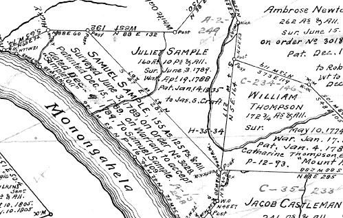
Section of the City of Pittsburgh's Warrantee Township
Map