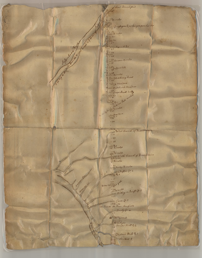
Chambers' Map From The Delaware To The Susuquehanna - 1685
Images
Click images for larger versions.
History
Record Group-26: Records of Department of State, Basic Documents, Indian Deeds, #18c. Iron gall ink on paper, 9"X 8."
William Penn's policy toward the native peoples of his province was distinctive. In contrast to most leaders of English colonies, he considered them equals. This attitude was consistent with his belief as a Friend (Quaker) that all people were children of God and with his intention to develop a "Holy Experiment" in which people of diverse backgrounds would live together harmoniously. As far as possible for a European, he attempted to understand the Native Americans. He tried to learn their language; went unarmed to their villages; played their games; and purchased their lands, sometimes buying the same tract from several different groups.
The indigenous peoples in the area settled by early immigrants to Pennsylvania were not numerous. Possibly, not more than 15,000 lived within the colony's boundaries. Those who inhabited the area settled by the early colonists were the Lenni Lenape, called by the English the Delaware. They were divided into several sub-groups, including the Munsee (Wolf), Unalachtigos (Turkey), and Unamis (Turtle). Other groups inhabiting the interior of the province included the Shawnee, who were scattered throughout the area, the Seneca in the Northwest, and the Susquehannocks, along the lower Susquehanna River, but who had abandoned that area by the time of Penn's arrival.
After Penn's return to England in 1684, he authorized Thomas Holme to negotiate the purchase of additional land. Holme, Penn's "surveyor-general," selected the site for Philadelphia and planned the city between South and Vine Streets and the Delaware to slightly beyond the Schuylkill River. During the early and mid-1680s, he served in Pennsylvania's legislature and was acting president of the Council and acting governor when he finalized a purchase of territory that he instructed Benjamin Chambers to map.
Holme wrote to Lenni Lenape leaders Shakhoppen, Secane, Mailibar, and Tangoras, identifying the area that he had purchased and what he had paid for it. He also indicated that "Benjamin Chambers… with a convenient number of friends to assist him" would "mark out a westerly line" that was to run from the Delaware to the Susquehanna River in the vicinity of present-day Washington Boro.
Holme's letter reveals much about Penn's relationship with the native people and their culture. He acknowledged the leadership of the "Indian Kings" and addressed them as "my very loving friends" from whom he had purchased land of which they were the rightful owners and which he intended to have defined on a map. Nevertheless, he demonstrated his awareness of their possible hostility by warning that he did not expect opposition but rather cooperation from them. He described the extent of the purchase in their terms, as the distance a man could "go in two days," which would have required fast walking. The distance between the Delaware and Susquehanna was more than sixty miles. Holme paid for the purchase in Indian currency: "Two hundred fathom of Wampum" and goods such as shirts, shoes, knives, bells, tobacco boxes, and (inconsistently) guns.
Why Holme selected Chambers is not clear. Chambers was a Friend who arrived in Pennsylvania in 1682. As one of the "First Purchasers," he owned approximately 5,000 acres of land in the vicinity of Plymouth Township in Philadelphia County. He was president of the Society of Free Traders, and served as sheriff "for the lower part of the county," and may have been associated with the provincial land office.
The map that Holme commissioned Chambers to draw is inclusive. It identified the Delaware's tributaries, including the Schuylkill River; both branches of the Brandywine; Darby, Crum, Ridley, and Chester Creeks as well as rivulets, runs, brooks, and rivers such as the Conestoga farther into the interior. Transportation arteries including Indian paths are marked. Also important are the structures Chambers noted. Houses suggest that even at this early date (1685) rural areas well beyond Philadelphia were inhabited, and the mills indicate the area's economic activities. Evidence that the Susquehannock Indians had departed from the lower Susquehanna River Valley is provided by the labels "Fort Demolished" at the sites of their former towns along the Susquehanna River.
Transcript
(spelling and usage retained from original document)
[Inscriptions From Top to Bottom]
Susquehanna River, R 45 Deg W
Fort Demolished
Rivulet
Grist Mill at [?] Cr.
Rivulet
Raccoons Rivulets
Prospect Hill
Rivulet
Narbury Cr
Long Meadows
Meadow Brook Meadows
Grape Fruit Valley
Great Indian Pat Marked
Rivulet
[?] River
West Branch of Brandywine
[G---]
Rivulet
North Branch of Brandywine
Rivulet
Rivulet
Rocky Rivulet
Chester Cr.
Foot Path
Rivulet
Ridley on [?] Cr.
Corsa's Creek
Wm Gorst
Rivulet
Swedes Mill R.
Clayton's Mill R.
Schuylkill R.
Delaware River