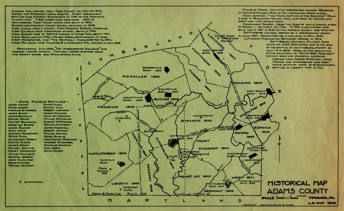
Leo Wilt Historical Map for Adams County - 1942
Images
Click images for larger versions.
History
Manuscript Group 11: Map Collection, Leo Wilt Historical Maps, 1941-1946, Adams County, 1942 Ink on paper, 9" X 13".
This map, though created in 1946, with its inscriptions and the printed material that surround it reveals much that is significant about early Pennsylvania. Nevertheless, viewers of the map will notice that it is not all-inclusive. Only one landmark of the most famous event that occurred in Adams County, the Battle of Gettysburg that almost 200,000 Union and Confederate troops fought from July 1 to 3, 1863, is indicated though the battlefield and cemetery are mentioned in the printed materials.
Despite what the map does not indicate, it demonstrates the land policy of the proprietors. In nearly every tract that Thomas and Richard Penn opened for sale, they reserved a parcel of ten acres for every 100,000 that they sold. Their purpose was to hold the acreage until the area's population increased, which would enable them to sell portions of it for a higher price. In what became Adams County, they retained the 43,500-acre" Manor of Mask." Although the state legislature passed the "Divesting Act" in 1779 confiscating the proprietors' unsold lands, it permitted them to retain their manors.
The map's notations also reveal much about the state's local political organization. The largest spatial local units of government are counties, authorized by the legislature and governed by elected commissioners. Adams, consisting of 339,133 acres covering 531 square miles was formed from York County in 1800, and reflected the area's inhabitants desire for courts closer to their residences. Named for the nation's second president, John Adams, it exemplifies the respect that some early Americans had for the new nation's leaders. Within counties are cities, of which Adams County has none; townships, twenty-one of them in Adams County, two of which were named for other early national leaders: Benjamin Franklin and Alexander Hamilton; and boroughs the largest of which is the county seat of Gettysburg, designated as such in 1806. Pennsylvania's cities, townships, and boroughs are governed by elected officials.
The names of the "pioneer settlers" as well as of some townships and boroughs emphasize one of Pennsylvania's most distinctive characteristics - ethnic and religious diversity. The townships of Reading and Oxford indicate English influence; Tyrone and Latimore, Irish or Scots-Irish; and Germany may reflect the presence of settlers from these countries. Among the early residents were immigrants from German-speaking lands: Peter Arendt, Andrew Schreiber, Nicholas Weirman, and others. Of Scottish and Irish origins were William Gilland, David McNaughy, and Robert McPherson. Duncan Evans was of Welsh background. Walter Buchanan and David Wilson had a Scottish heritage. The map implies at least the temporary residence of African Americans also. Adams Countians worshipped at the Roman Catholic Conewago Chapel and certainly in Presbyterian, Lutheran, and Reformed churches, though none are shown on the map. They studied first at the school operated by the "Kreutz Kirche" (Church), probably German Lutheran and Reformed and at the Lutheran-run Gettysburg College and Theological Seminary.
The residents' early economic activity can be discerned from the map. McCallister's Mill located south of Gettysburg, suggests the milling of grain probably grown on farms in the county. Maria Furnace, in the southwestern corner of the county, marks the site of the county's iron manufacture. Roads and railroads are evidence not only of a transportation industry but also of a commercial economy that required means of shipping the county's products to distant markets.
Also moving across the county were slaves traveling from bondage to freedom on the "Underground Railroad." Of necessity, the identities of the "conductors" and "stations" were secret. The Mason-Dixon Line, completed in 1767, formed the southern border of Adams County and divided the "free" state of Pennsylvania from the "slave" state of Maryland. Fugitives crossing the border were not secure from the "slave chasers" in Adams County, especially after the passage by Congress of the Fugitive Slave Act in l850 that made escape more difficult. Among the places in the county where runaway slaves could get help as they traveled north, some eventually to Canada, were McAllister's Mill and the Wright House, north of York Springs, both marked on the map. There may have been other "stations" as well, the locations of which were known only to the "conductors" and "passengers." How well organized the "railroad" was is a matter of conjecture. Indeed, some fugitives are said to have trusted no one and made their way to freedom through Adams and other border counties such as Chester, Lancaster, York and Cumberland, on their own.
In these ways, Adams County was somewhat typical of pre-modern Pennsylvania as a whole. Private ownership of land and land speculation was normal. Government was representative at all levels. The population was of varied origins. The economy was diverse. At least some of its residents did what they could to abolish the institution of slavery that was the basic cause of the Civil War, a decisive battle of which was fought on the outskirts of Adams County's largest borough, now known also as the site of President Abraham Lincoln's famous "Gettysburg address."
Transcript
(spelling and usage retained from original document)
Adams was formed from York County on Jan. 22, 1800. Named for President John Adams. First permanent settler was Andrew Schreiber in 1734 on the Conewago in Union Twp. First court was held June 1800 at Gettysburg. First Court House erected in 1829. First Judge – John C. Henry, First Sheriff – George Lanerils. First Church was Conewago Chapel, built 1740. First school was at Kreutz Kirche in Union Twp. About 1747. First road laid out 1742 – Marsh Creek Settlement to York. First newspaper was “The Sentinel” published Nov. 12, 1800. First railroad was Hanover & Littlestown RR opened in July 1838.
Preceding the Civil War, “The Underground Railroad” ran through Adams County. Two well known stations were the Wright House and McAllisters Mills.
Manor of Maske – One of the Proprietary Manors reserved to Thomas and Richard Penn in 1741 containing 43,500 acres.
Mary Jemison – “The White Captive of the Genesee” a girl in Buchanan Valley was captured by Indians and spent her life among them.
Conewago Chapel – Here the Jesuits had a mission, the first in Penna., as early as 1720. In 1740 a log chapel was built and in 1797 a part of the present church was erected.
Gettysburg college opened as a preparatory school in 1827. Organized as a college in Nov. 1832. Lutheran Theological Seminary opened in 1824. Gettysburg National Military Park contains over 2,400 acres and is the site of the Battle of Gettysburg, fought on July 1-2-3, 1863. Here, at the dedication of the cemetery on Nov. 19, 1863, President Lincoln gave his immortal address.
Captain John Hanson Steelman, an Indian Trader and Interpreter was first white settler west of Susquehanna, settled in Liberty Twp. In 1712.
Historical Map Adams County
Towanda, PA
L.E. Wilt, 1942