Kings Quarry
During the late spring of 2003, CAP conducted surface collections and mechanical excavations of the King's Quarry site (36LH2) in Lehigh County. This site is a key contributing element of the Hardyston Jasper Prehistoric District and is one of only six remaining jasper quarries in the Reading Prong physiographic province of eastern Pennsylvania. The site was reported in the late 19th century by Henry Mercer and was later recorded with the PHMC by Richard Jordan of Bryn Mawr College. Later, in the 1990s, the site was mapped and sampled for artifacts by the late James Hatch, who presented his findings from this and other Reading Prong jasper quarries in a report submitted to PHMC.
The site is situated on a slight slope adjacent to a small stream. It is about 20 acres in size. Most of the site is in agriculture fields but a 5-acre area is in mature trees and this contains numerous Native American dug quarry pits still exposed on the surface.
The site is dated from diagnostic artifacts identified by both Hatch and CAP, and C-14 dates. It was used from Paleoindian through Late Woodland times (ca. 12,000 to A.D. 1550). Although the site is a quarry, CAP's investigations recovered a small number of hunting, butchering and hide-working tools in addition to the huge amount of the usual quarrying and workshop-related materials.
The structure of the site appears to be that of an open-pit quarrying location encircled by workshop areas. As many as 22 quarry pits previously mapped by James Hatch are present in the wooded core of the site, and a much larger pit was identified in an adjoining open field during the CAP investigations. Presubably, there are other large pits and the wooded area may be underlain by a large ancient pit covered by the more recent smaller pits. CAP concentrated on controlled surface collections of the field, backhoe trenching through a series of overlapping quarry pits in the wooded area, and mechanically excavating a much larger step-trench in the massive, back-filled crater in the adjoining open field.
Within the field next to the wooded quarry-pit area, and adjacent to the larger, unforested crater, was a small topographic rise that measured 50 by 80 feet. This is adjacent to an area where waters seeps out of the ground today and may have been a spring in prehistoric times. This corner of the site, which was extremely dense in lithic materials, produced three very noteworthy surface finds in close proximity to one another. These finds are from the Paleoindian Period and consisted of: an unfinished, though nearly completed, Clovis point; a unifacial endscraper; and a sidescraper made on a large flake. This occupation represents one of the first visits to the site. After the open field was re-plowed and rain-washed, the area where these particular surface finds had been recovered was then gridded into 10-foot squares and collected entirely. Although another potentially early endscraper was found during these efforts, the deposit also proved to contain Late Archaic to Transitional artifacts and could not be interpreted as a single occupation. Re-opening of small backhoe trenches that had been dug by project engineers during septic tests indicated that this particular part of the site contained a shallow plowzone over undisturbed subsoil.
Following this collection, the remainder of the newly plowed field was divided into 10-foot squares within micro-topographic zones, and a stratified 5-pecent random sample of the site was obtained. This should prove interesting to analyze, as there appeared to be spatial differences in types of debitage, and in quality and coloration of material, across the greater plowed area.
After these collections were complete, a step trench was dug with a track hoe through the wooded area and up to the edge of the Paleoindian occupation. This trench revealed the profile of the prehistoric quarrying operations. These extended at least twelve feet from the surface and in the area adjacent to where the Clovis point was found, the prehistoric pit reached a depth of 23 feet. Such evidence of excessively deep quarrying echoes Henry Mercer's finds at nearby Macungie where test excavations revealed over 18 feet of soil that was presumably disturbed through open-pit prehistoric quarrying.
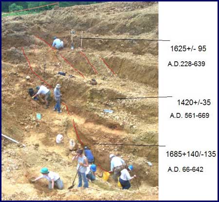
Profile view of the massive step trench excavated into the prehistoric jasper quarry at 36LH2 in Lehigh County. The prehistoric miners had excavated to a depth of 23 feet.
The Native American miners were not excavation through solid rock but bedrock that had "decayed" to soil. It was found in the form of nodules, weighing hundreds of pounds. Recent work by Dr. Frank Vento of Clarion State University has demonstrated that the jasper nodules are situated between a schist formation and the Hardyston quartzite formation. The only digging implements that were found were large flat pieces of rock that may have been used as hoes. We assume that most of the digging was done with antler picks, bone hoes using elk scapula (shoulder bone) and wooden sticks. Digging sticks are probably one of the oldest human made tools but they are rarely preserved in the archaeological record. As expected, numerous hammerstones were found that would have been used to break up the nodules into manageable pieces.
With the first visit to the site during Paleoindian times, jasper was recovered from the surface, with little digging involved. By Early Archaic times, open pit excavation was required to recover good quality material. With each subsequent visit, more holes were dug, in some cases backfilling earlier excavations and deepening others. Eventually there were probably several large quarry holes around the site of twenty feet or more in depth. The large crater adjacent to the Paleoindian occupation probably reached its maximum depth around 3000 years ago during the Transitional or Early Woodland use of the site. It was at least 80 feet in diameter. It is somewhat ironic that, although several acres of earth were moved over a 10,000 year period, the area of the Paleoindian occupation was never excavated.
Several carbon samples were collected from this pit for carbon 14 dating purposes. We were not able to collect any samples from the outer edges of the pit, thus dating its maximum size but we collected four samples from a layer of soil that represents the initial backfilling of the pit. These date to early Middle Woodland times as follows.
Carbon 14 years
1420±35 BP
1610±80 BP
1625±95 BP
1685±140 BP
Corrected to calendar years
AD 561-669
AD 316-619
AD 228-639
AD 66-642
The Middle Woodland Period represents the beginning of a decrease in the use of jasper and this is probably the reason that the quarry began to backfill through natural erosion. During Late Woodland times, jasper tools are usually very small and rather than digging, the Native Americans may have simply collected jasper from the surface that previous people found too small to use. The top eight feet of soil over this quarry pit is a rather homogenous soil and seems to represent a single backfilling event. It is probably an effort by the first farmers in the area to recover some of the land for agriculture.
Besides the extent of the prehistoric quarrying, another eye-opening aspect of the study is the variety of jasper present at King's Quarry. Indeed, the natural lithic variation at this quarry appears to far surpass that of other related sources such as those found at nearby Macungie and Vera Cruz. Although King's Quarry contains a notable amount of the typical opaque brown, yellowish brown and yellow jasper, some of the material includes other vivid colors as well as varying textures and lusters. Color variations include dark brown, black, gray, mahogany-like reddish brown, maroon, blue, white, buff, and-in rarer instances-deep green. In addition, many specimens are variegated or banded in two or more distinctive colors. The material also varies from opaque examples with a dull luster to translucent examples with shiny, glassy, or waxy luster.
An alarming aspect of this variation is that, if individual patches were flaked off of larger pieces and looked at as single specimens, many would be classified as non-jasper lithic types. For example, some of the translucent material is chalcedony, and some of the dark opaque materials would normally be classified as various cherts or flints. Indeed, there are relatively common examples where a single specimen of rock collected from the site contains a thick, solid mass of black chert/flint on one face and a mass of typical yellowish brown jasper on the opposing side.
Certainly, the variety found at this site has implications for sourcing studies, and identifications of "exotic" materials in local assemblages. In addition, the extreme range of variation from this one source further frustrates attempts to confidently define materials through casual visual examination only.
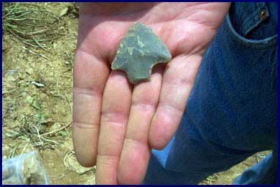
3,500-year-old Lehigh Broadspear projectile point found on the surface at King's Quarry, 36LH2