Monongahela River Basin
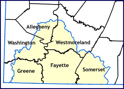
The subbasin includes all of Fayette County, and parts of Allegheny, Greene, Somerset, Washington, and Westmoreland Counties. The terrain consists of broad upland flats cut by deeply entrenched streams. The major archaeological research has been conducted by the Carnegie Museum and they have excavated numerous sites from all time periods. California University of Pennsylvania has also conducted significant research in the Lower Monongahela Valley and they continue to do so through summer field schools. If you are interested in learning more or participating in the archaeology of the region, we suggest you contact these institutions. Also, the Society for Pennsylvania Archaeology has several chapters in the region and they can also be contacted through the Pennsylvania Archaeology Society's website.
Approximately 1,850 archaeological sites are recorded in the Monongahela River Subbasin. Of these, 893 sites can be assigned to specific prehistoric time periods and 239 can be assigned to specific historic time periods.
Paleoindian Period
The Paleoindian period represents the earliest occupation of the region, during which the Monongahela River Subbasin was sparsely occupied by small groups of foragers. The climate was evolving from Ice Age conditions and plants and animals were very different in the Monongahela Valley than they are today.
Only 18 Paleoindian sites have been recorded in the Monongahela River subbasin. Six are located along the Casselman River and the remaining sites are scattered in upland settings. Three of the Casselman River sites were investigated as part of PennDOT's Meyersdale Bypass project. Like many Paleoindian sites, the main evidence for the Paleoindian occupation was a single fluted point at each of these sites. There were probably more artifacts but they were not particulary distinctive and could not be distinguished from the artifacts of other time periods. We assume these represent nuclear family groups that foraged over large areas. The stone they used for making tools was frequently local but some originated as far away as Ohio and western New York State. Their annual movements or territory may have covered 200 miles or more in search of food resources.
Early and Middle Archaic
During the Early and Middle Archaic periods people lived in small groups, moving their camps frequently to hunt, fish, and gather wild plant foods. Territories were somewhat smaller than during Paleoindian times. The climate and vegetation gradually took on its modern characteristics by Middle Archaic times.
There are approximately 160 Early and Middle Archaic sites recorded in the Monongahela River subbasin, but few have been excavated. Sites on slopes, saddles, and ridge tops are common, indicating that the hunter-gatherer groups utilized a wider variety of environments and resources compared to Paleoindian times.
The Kinsinger Site (36So51) is on high ground overlooking Elklick Creek and was investigated as part of the Meyersdale Bypass project. The site revealed evidence of a Middle Archaic house with a central fire pit. This represents one of the earliest structures ever found in the Commonwealth. Two deep features, identified as earth ovens, were also found at the site. The site was interpreted as a base camp. By the end of the Middle Archaic, people were living in small extended family groups and moving on a regular basis to the location of seasonally available food resources.
Late Archaic and Transitional Periods
Population density increased during the Late Archaic and Transitional Periods. Groups of related families established base camps, which they moved less frequently than in earlier periods. Smaller, special-purpose camps were established for hunting and collecting resources at locations distant from the base camp. Seed grinding tools and fishing equipment are more common. The climate, flora, and fauna were similar to the present.
Over 300 Late Archaic and Transitional Period sites are recorded in the subbasin. The Middle Archaic Kinsinger Site was also occupied repeatedly during the Late Archaic and Transitional periods. The site revealed fire pits with radiocarbon dates indicating at least three separate base camp occupations within a period of 1000 years. This period is characterized by larger base camps created by groups of families converging on the location of seasonally plentiful resources such as fish runs and the harvesting of nuts such as acorns, butternuts, and hickory nuts. Although there are large numbers of sites from this time period, very few have been systematically investigated, so we only have a very general picture of developments during the Late Archaic of this region.
Early and Middle Woodland Periods
The Early and Middle Woodland periods in the Monongahela River subbasin are well known relative to other regions of the Commonwealth. They also seem to be part of a different cultural tradition than the rest of Pennsylvania, one more related to cultures located further west in the Ohio valley. The people are more sedentary and houses become more permanent. People began using pottery and were on the fringes of the trade networks that developed in the Ohio River Valley to the south and east.
There are approximately 230 recorded Early and Middle Woodland sites in the subbasin. Included are several burial mounds -Lynn Mound and Riverview Mound. Excavations at the latter site produced mica and copper awls, and exotic materials indicating trade with Adena and Hopewell people in the Ohio region.
Sites in the Monongahela River subbasin are generally camps rather than hamlets or small villages such as those found further down the Ohio River Valley. For example, thirteen Early Woodland sites were identified in the Meyersdale Bypass survey in the Casselman River valley. All were interpreted as short-term camps; no long-term camps or hamlets were found.
A number of Early and Middle Woodland sites have been investigated along the Youghiogheny River. One site excavated as part of a Consolidated Gas Transmission Corporation pipeline construction project revealed a variety of features, including fire pits, large roasting pits, storage pits, and evidence of posts suggesting that houses were present. Radiocarbon dates indicated occupations during both the Early and Middle Woodland periods. Over 200 pieces of pottery were found but were in very poor condition.
The Billy #3 Site (36WM717) is situated on an upland flat overlooking Sewickley Creek. The site produced a pattern of postmolds, indicating a rectangular house, along with a fire pit, a storage pit, and an earth oven. The age of the site was determined on the basis of its pottery, which is characteristic of the Middle Woodland period. Hickory and walnut shell, blackberry, raspberry, and one squash rind were found, representing a sample of their diet. A burial mound (36Wm50) that had been heavily disturbed was located 60 m to the northeast of the hamlet. Excavation revealed a disturbed stone crypt with fragments of a human skull and six teeth.
Late Woodland Period
After AD 900, the region was the center of the Late Prehistoric Monongahela culture. People lived in fortified villages and grew corn, beans, and squash. The quality of the pottery is improved and a variety of ornaments appear in the archaeological record.
Over 350 sites dating to the Late Woodland period have been recorded in the Monongahela River subbasin; more than any other time period. The sites include a number of large villages, as well as smaller hamlets and special-purpose camps. Village sites are often located on upland flats, whereas smaller sites are along streams. Seven Monongahela village sites were investigated in the Casselman River valley, as were 14 hamlets and camp sites.
One of the larger and most significant excavations was the Gnagey No. 3 site (36So55). The site consisted of two villages at the same location. This is very common for Monongahela sites. They returned to the same sites where the trees on the villages and the surrounding farm fields were not overly large. At the Gnagey site, the earliest had five houses with central hearths in a circular pattern around a central plaza. The second village also had five houses, along with a large number of cooking hearths and roasting pits. A stockade surrounded both villages. Most Monongahela villages are surrounded by wooden stockades, and it is assumed that warfare was common. However, it is not known whether they were fighting among themselves or with more distant neighbors. An elaborate material culture is generally associated with Monongahela sites, including ornamental items acquired through trade. Excavations at the Gnagey site included stone pendants, stone and clay pipes, and bone and shell beads. In addition to stone tools, fish hooks, awls, and other tools were fashioned of bone and antler.
Recent excavations at the Mon City Site (36Wh737) indicate that wild plant foods supplemented the agricultural produce. Four types of animals provided most of the meat - deer, wild turkey, turtles, and fish. However, burned bones of many smaller animals, such as squirrel, rodents, and snake, were also found.
The Gnagey village plan, with houses surrounding a central plaza, is common until around 1550. Some of the houses have attachments that appear to be extra storage structures or for food processing. Beginning in the mid 1500s, a large central structure appears in the plaza at some sites and these have several attached structures. The Throckmorton site and the Folley site date around 1600 and these each have a central structure with numerous attachments. In fact, in plan view, these take on the appearance of flowers and are called "petal houses." Archaeologists have mapped and analyzed these structures in detail but their specific function continues to be questionable. The best explanation to date is that the petal houses were somehow used to store or process furs used in the fur trade with the Europeans.
The Monongahela were dispersed by 1635, and much of the region was unoccupied at the time of European Contact. The demise of the Monongahela is somewhat of a mystery. Glass beads are found at some villages, so the Monongahela culture was in contact with Europeans, but probably only through Native American middle men. We have no written accounts of Europeans ever meeting these people and there is no direct evidence of catastrophic warfare among Monongahela villages. As elsewhere in the New World, European diseases likely decimated these people prior to their ever meeting the Europeans.
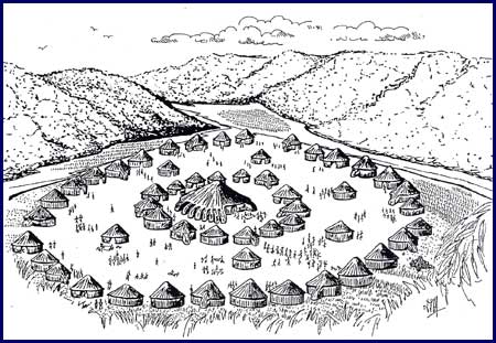
Artists's rendering of the Foley Farm Site (Illustration by Kim Lackey Stone)
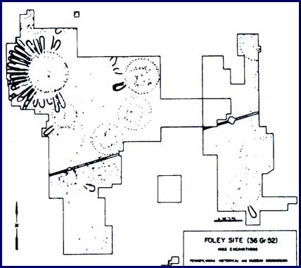
Drawing of postmold patterns at the Foley Farm site, showing a petal house.
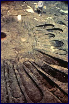
The Foley Farm petal house after excavation.
Historic Period
The Historic Period followed European contact with Native Americans in the Monongahela River drainage.
There are 352 recorded historic sites in the subbasin. Military sites include Fort Necessity, Bouquet's Redoubt Camp 13, Fort Gaddis, and the Bushy Run Battlefield. Industrial sites include the New Laurel Iron Furnace and the California Glass Works.