Union County
The Union County Industrial Development Corporation (IDC) is proposing to create large wetlands at the back (west) edge of a floodplain on the West Branch of the Susquehanna River, and to use this wetland to filter storm water from an Industrial Park that would be built in the adjacent uplands. The area adjacent to Site 36UN10 is slated for wetlands creation for the storm water management facility, and this site was the primary focus of investigation by CAP. At this site, CAP conducted controlled surface collections, backhoe trenching, assessment by geomorphologist Frank Vento, and limited excavation to examine artifacts, stratigraphy, and features incidentally revealed by one of the stratigraphic test trenches. IDC will have surveyors map the entire site boundary in order to avoid it during wetlands creation. Eventually, however, at least one outfall pipe will have to be run from the wetlands across the levee in order to drain off the filtered storm water.
Excavation of one of the trenches opened for geomorphological investigation revealed a rich, stratified subsurface deposit that appeared to extend from Late Archaic through Transitional periods, and into the earlier part of the Middle Woodland (a date range from ca. 2,000 B.C. to A.D. 200). Notable findings include a concentration of wood charcoal in association with a cache of chalcedony blades, a slate gorget and an unusual faceted graphite sphere. Carbon collected for analysis indicated that the cache was associated with the Middle Woodland period, ca. A. D. 200.
In addition to these artifacts and features, a large shallow basin was present, and this too proved unusual and unanticipated. Excavation of this feature revealed a thin, discontinuous sheet of charred wood lying across the bottom and extending up the sides of the feature. Upon excavation of the overlying fill, it eventually became obvious that this mat of carbon was more than likely a lining in the pit. A large portion of this sheet was taken out in a block and will be examined further in our lab. The remainder was recovered for flotation, wood identification, and C-14 dating. Contents of the pit included two typical Lamoka projectile points of chert and a less distinctive stemmed point of argillite or siltstone. However, it is not believed that these were part of the feature and were probably mixed in with the pit fill.
CAP wishes to thank Mr. Charles Hannon and Mr. Bob Hershey for their volunteer assistance on this project. The help of PHMC conservators was invaluable, and special appreciation is extended to Ms. April Berry, Mr. Brian Howard, and Ms. Brenda Reigle.
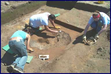
Excavation of a prehistoric pit at Site 36UN10 in Union County. The dark mass in the pit is a remarkably well preserved, charred wood lining. The pit was buried and sealed by flood sediment from the West Branch of the Susquehanna River.